Natural Attractions
.

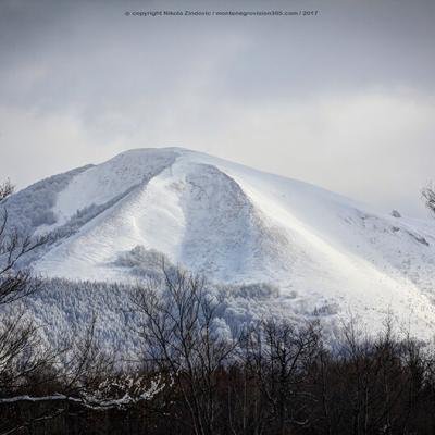
Bjelasica
Bjelasica stretches from the right bank of the Tara and its northwestern parts belong to the municipality of Mojkovac. It geographically represents the continuation of the mountain range that stretches from Piva mountain, across Durmitor and Sinjajevina, and then goes on from Bjelasica to Komovi and Prokletije. Extending over 30 km in width and length, it covers an area of about 620 square kilometers. Bjelasica is certainly one of the most luxurious mountains in the south of Europe when it comes to its wealth of flora and fauna. It is covered with greenery in all altitude zones with an abundance of water and mountain lakes. It has over 2000 plant species in 26 plant communities and 86 types of trees with specimens over 400 years old. Bjelasica, which covers a large part of the municipality of Mojkovac, is a true splendor of natural beauty in the winter and summer months. In the eyes of skiers, its expanses are a challenge for skiing on rugged terrain, as well as for walking on snowshoes. In summer, they are a real paradise for mountaineers, bikers and other nature lovers.
Bjelasica is one of the biggest potential sites for mountaineering and tourism in Southern Europe. The Tara and Lim rivers wash it with pristine water. Glacier lakes beckon with their secrets, villages and katuns with their hospitality. The highest peak of the north-western part of Bjelasica is Razvršje (2033 m). This peak has extremely steep sides and sharp slopes. In the east, Razvršje is connected to the peak of Crna Lokva, which descends steeply into the valley of the Tara River. Between the peaks of Razvršje and Crna Lokva from the south, and Bjelogrivac, Marinkovac and Mučnica from the southwest, lies the valley of the Bjelojevićka River. There is a low valley with the small Rudnica River carved between the peaks of Marinkovac and Mučnica. On the sides of this river there are deposits of lead-zinc ore. The main mountain ranges, built of quartz shale and limestone, developed on the Dinaric axis. Unlike other Montenegrin mountains, Bjelasica has a volcanic-silicate composition, so the presence of clastic rocks also determined the abundance of surface water.
Sinjajevina
Sinjajevina is the largest pasture in the Balkans. Sinjajevina is a vast Montenegrin mountain that lies between Tara Canyon, Drobnjački Lakes, the Tušina river and the sides of Gornja Morača and Pčinja. Although rarely visited, Sinjajevina is, paradoxically, the most spacious mountain in Montenegro - it occupies an area of over 60 square kilometers. The greater part of Sinjajevina is actually an undulating plateau, with a uniform landscape of karst sinkholes, fields and grassy heads. It is 35 to 40 km long and 10 to 15 km wide. It has the appearance of a high dissected surface with an average height of 1,600 to 1,700 m. Sinjajevina is built mainly of Triassic and, to a lesser extent, Jurassic limestones and dolomites. At the points of contact between limestone and dolomite, numerous coves have formed. These coves have an elongated shape, and the local population calls them fields. Okrugljak Bay is elongated in the direction north-west to south-east. It is 1 km long, and it is about 250 m wide. At its bottom there is a sinkhole into which the water of the smaller Ružica Spring, which rises on the north side of this cove, plunges. North-east of the Ružica church there are the coves: Knezdo, Doke and Barice, which used to be a gathering place for the ice that moved towards the Ljevaka Valley. Northwest of Jablanov Vrh, Okrugljak and Mutna Lokva, there is one of the largest coves of Gornja and Donja Provalija. This cove represents a cirque that once moved the glacier towards the Ravnjak River Valley. Sinjajevina is bordered by canyons of powerful mountain rivers. The Morača flows in the south, while the Tara surrounds this area on the eastern and northern sides. Due to its geographical features, the climate in Sinjajevina is very harsh. Due to its undulating plateau character, Sinjajevina is a magnet for cold air and clouds, which are said to be the last to leave (when it's already very clear all around). There are over six peaks above 2,000 meters on it (Baba's Tooth - 2,257 m), so it can be classified among the high mountains of Montenegro.
This mountain unit is mainly built of Triassic and Jurassic limestones and has dominant karst and glacial landforms in its morphological structure. With a pasture area of 120,000 ha, on which 200,000 sheep can graze, Sinjajevina is one of the most important mountains for sheep pasture. The northeastern part of Sinjajevina belongs to the municipality of Mojkovac and it is where the spring and summer katuns of its herdsmen are located. The vast surface of Sinjajevina, bordered by the magnificent canyon of the Tara River and decorated with Lake Zabojsko, with excellent terrains for Nordic skiing disciplines, represents a God-given area for the development of mountain tourism. It is characterized by the simplicity of its natural forms and good potential opportunities for certain winter sports, summer recreation and hiking. An important factor in the individual characteristics of Sinjajevina is its plant cover, primarily grass. In this part of Sinjajevina, there are the Bjelopavlići katuns, which were granted to them by Prince Nikola after the liberation wars.
Prošćenske Mountains
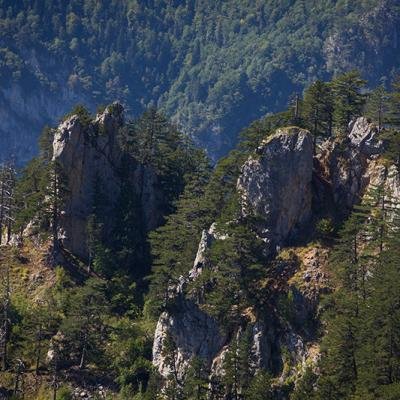
North of the Tara Valley, at an altitude of about 1600 m, are the Prošćenske Mountains. These mountains are located in the northwestern part of the municipality of Mojkovac. The Prošćenske Mountains are also an accessible area through which easier communication with the neighboring municipalities of Pljevlja and Bijelo Polje is possible. The highest peak is Ljeljeni Vrh (1856 m), which is located above the place where the Tara River Canyon begins. On its southern side is Veliki Do Cove. The direction of this cove is northwest-southeast. In the south, Veliki Do Cove falls into the canyon of the Tara River with a steep limestone section. In the west, Ljeljeni Vrh transitions gently into the spacious plain of Stupsko Polje. North of Stupsko Polje stretches the limestone cove of Crvena Lokva, which runs from southeast to northwest, and is also inclined in that direction. Numerous sinkholes are spread along the bottom of the cove. It is assumed that Crvena Lokva was created when the Tara River had a much higher level, while a small river flowed through Crvena Lokva itself. Over time, the Tara deepened its bed, and the small river that flowed through this cove began to sink and eventually disappeared. The lower part of Crvena Lokva is surrounded by a saddle, 1440 meters above sea level. Crvena Lokva is above the Tara River Canyon at a height of 760 m.
The area of the Prošćenske Mountains has a large number of coves and sinkholes. To the north-east of Ljeljeni peak is Petrovića Omar, a cove and a cliff covered with dense spruce and fir forest. To the north-east of Petrović Omar there are two smaller coves, Jokića Krlje and Meki Do. To the east of these two, there is the largest cove in the Proscenje area, Burenski Do. The direction of the cove is from northeast to southwest. The length of the Burenski Do is 3.5 km, and the width is 1.5 km. To the east of the cove rises the Buren Limestone Ridge (1631 m). The slightly lower peaks of the Prošćenske Mountains are: Goveđa Glava (1656 m), Ledenice (1689 m), Svevidje (1556 m), Zabrćka Glava (1752 m), Baltića Šiljak (1673 m).
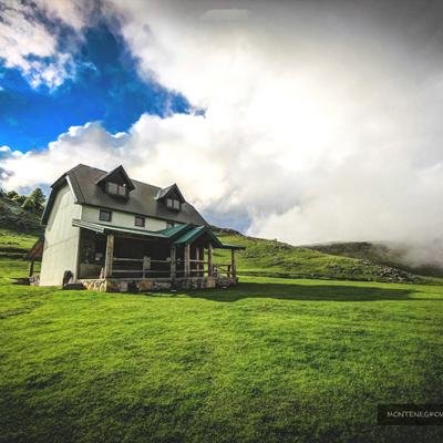
Having seen the natural beauty of these areas, the members of Prošćenske Planina Mountaineering and Sports Club in Mojkovac, with their joint efforts, stone by stone, built the mountain lodge "Prošćenske Planina" for three years. Actually, they had the idea to build their own place for rest, a refuge in untouched nature, a port for travelers.
The Tara River
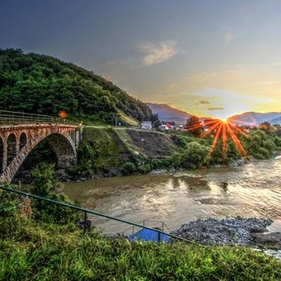
The Tara River is 158 km long, and has 14 tributaries, as well as an incredible 69 rapids, so it is not surprising that it is the most popular destination for rafting in all of Montenegro. Another feature, which only adds to its admiration and untouched reputation, are the waterfalls - as many as 40 of them, of which Crna Vrela, Bijela Vrela, Đavolje Lazi, Sokolovina and Bijeli Kamen stand out the most. The crystal-clear, lush mountain river Tara originates from the confluence of the two rivers Veruša and Opasnica, flowing in a northerly direction through the territory of Montenegro, further into Bosnia and Herzegovina, where it joins the river Piva, forming the second river, Drina.
The Tara got its name from the Illyrian tribe Autarijati, who lived along the river in the 4th-5th century. In 1937, the picturesque Đurđevića Bridge was built on the river, which for a long time represented the only road connecting the south and north of the country. The wonderful architecture of the bridge, 150 m high, consists of five huge arches with a total length of 370 m.
Tara is the largest river in Montenegro, which represents the largest natural reserve of drinking water in Europe. The canyon of the Tara River in Montenegro is one of the most fascinating sights in Europe, if not in the whole world. The turquoise blue color of the crystal clear water cuts through the northern edge of the Durmitor National Park, and forms a 1300 m deep canyon – a natural wonder that invites nature and adventure-lovers to explore.
Also known as the "Tear of Europe", the canyon of the Tara River is the longest canyon in Europe, and it is only behind the "Grand Canyon” on the Colorado River, in the world. The canyon of the Tara River is one of the rare sights that truly leaves you breathless. In addition to being one of the undoubtedly most beautiful sights when it comes to the nature of Montenegro, the beauty of the Tara Canyon is also recognized by UNESCO. Back in 1977, the Tara Canyon became part of the "Man and the Biosphere" program, thanks to its diverse flora and fauna.
Species of fish, such as trout, salmon and grayling, and other animals, such as eagles, vultures, bears, wolves and foxes, find a permanent refuge in the wilderness that surrounds the Tara canyon. The forests around the canyon abound with oak, black pine and ash trees, while the river's water is clean and drinkable along its entire course, which is just another indicator of the untouched nature of this area.
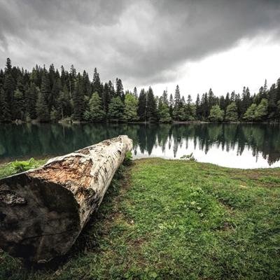
Lake Zabojsko
Lake Zabojsko is located on the north-eastern slopes of Sinjajevina, high above Dobrilovina at an altitude of 1477 m. Lake Zabojsko is 265 m long, in the west-east direction, and 165 m wide. The surface of the lake is 27,600 m², but due to its great depth of 19 meters, Lake Zabojsko is the 3rd deepest lake in Montenegro, right behind Black Lake and Captain's Lake.
Its name comes from the nearby village of Zaboj, which was well visited in the past, during the summer cattle drive. In the southern part, the lake has its greatest depth, 18.8 m, and thus is one of the deepest mountain lakes in Montenegro. Lake Zabojsko has no permanent tributaries, and it gets its water from precipitation, especially from melted snow. The lake can swell to 50 m long, after which the water recedes again. The water of the lake is clear, clean and transparent up to 8 m of depth. The water temperature in the summer is 16°C, while the surface of the lake is frozen for about three months during the winter. The lake is ideal for fishing enthusiasts, because the rainbow trout that the locals call "brkač" lives right here. On the shore of the lake you can enjoy the clear and cold water, the silence and peace that is broken only by the barely audible noise of the mountain spring. A macadam road leads to the lake from the village of Dobrilovina, which is located on the road Mojkovac - Đurđevića Tara. It is also possible to reach the lake with an all-terrain vehicle. If you go on foot, you can take the road, and there are also shortcuts that lead through the forest.
A footpath leads around the lake. The lake is not big, so you can quickly go around the whole area. Next to the lake there is also a source of drinking water. The surrounding forest, in which it is tucked away, is reflected in the water of the lake, which gives it a magnificent color. The view of the lake, which looks like it's from a fairy tale, the silence disturbed only by the birds, and the clean air is all you need to take a break from everyday life.
Lake Zabojsko is surrounded by a dense coniferous and beech forest. Due to its exceptional natural values, it is protected within the Durmitor National Park by a strict conservation regime.
Crna Poda
In the canyon valley of the Tara River, between Bistrica and Dobrilovina, at an altitude of 950 m, there is a black pine rainforest - Crna Poda, one of the most beautiful forest areas in Montenegro. This pine forest complex covers an area of 20 ha, and the average age of the pine trees in it, which reach a height of up to 45 m, is 400 years. The existing community of black pine in the Crna Poda reserve is of world importance, because it contains trees whose height and thickness have not been recorded until now. The total amount of wood in Crna Poda is 1,465.57 m³.
Below this forest, there is the Devil's Lazi, where the Tara narrows to just 2-3 meters. The Tara Canyon is an integral part of Durmitor National Park, which is registered as a UNESCO World Natural and Cultural Heritage Site. Integral parts of the Durmitor National Park are Crna Poda Forest and Lake Zaboj on Sinjajevina, which are located in the Mojkovac municipality.
Đavolje lazi
The Đavolje Lazi Gorge is located under the Crna Poda Forest, at the very entrance to the Tara River Canyon. Here, nature narrowed the river bed of the most beautiful European river to only 2-3 meters. This part of the canyon is a special challenge for lovers of wild beauty and extreme kayaking.
Tmajevac
Tmajevac is the place where the Ravnjak River flows into the river Tara, forming a small lake. This place represents the entrance to the National Park "Durmitor" as well as to the part of the municipality of Mojkovac that belongs to the UNESCO List of International Cultural Heritage. After this place, there is also the Đavolje Lazi Gorge. Tmajevac is best seen from the lookout point, known locally as Galev Krš (Gale’s Rock), where there is a monument dedicated to the famous local mountaineer, Džambas, which is located on the road to Đurđevića Tara.
Ravnjak
Ravnjak springs from below Pećarac. The upper part of the stream is about 2 km long, called Suvoravnjak. It got its name from the fact that there is no water in it throughout the year and it dries up. There is water in it during autumn and spring, as the snow melts on Sinjajevina. The main spring of Ravnjak emerges from under the road to Mojkovac - Đurđevića Tara. From these springs to the mouth of the Tara, the length of the stream is about 3.5 km. The 2.5 km long Ljevak Stream flows into Ravnjak from the left side. It divides the village of Bistrica into two parts. The average yield of the spring is about 1000 l/s. Ravnjak also receives several smaller tributaries in its lower part, which the locals call "makvas.”
The Ravnjak River is about 15 km from the center of Mojkovac, in the direction of Durmitor National Park and Đurđević Tara. It is located at the very entrance to the Tara River Canyon, next to the nearby Hotel Ravnjak, which makes this place very attractive and exceptional in many ways. At its end, the river Ravnjak flows into the famous Tmajevac.
Ravnjak, with beautiful, wild nature where you can often meet Roe deer and fawns near the water, is so clear that every stone can be counted and so clean that you can drink water from it.